
Map Your Way
Through
Pacific Northwest Wine Regions
Use Wines Northwest's
wine country maps to plan your touring itinerary.
Our maps provide an overview of the Northwest viticulture appellations and
will help you find the locations of wineries open to the public for wine
tasting.
Make the most of your wine touring time by choosing wineries that
are situated in geographic relationship with each to create your own
custom
wine trail.
You can also use our winemaking and
fruit-growing
overview calendars to consider the timing of your visit. Click on the Pacific
Northwest wine country region of your choice
shown
on the state and province maps below:
Washington,
Oregon, Idaho, British Columbia.
Click here for some
Wine-Touring Guidelines.
Washington, Oregon, Idaho
or British Columbia
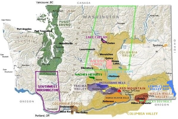
Washington State Wine Regions
Click on the region of your
choice to see
a detailed map including winery locations.

|
To
print map, RIGHT mouse click over the map and do one of the
following:
Internet Explorer
click on the “Print Picture” option;
Firefox click on “View image” then choose Print from the
browser pull down menu; or
Safari and Chrome click on “Open image in new tab”
then choose Print from browser pull down menu. |
Official Washington Appellations/AVAs


Other Unofficial Wine Country Regions


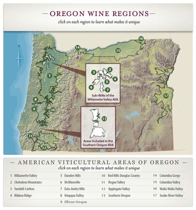
Oregon State Wine Regions
Click on the region of your choice to
see
a detailed map including winery locations.

|
To
print map, RIGHT mouse click over the map and do one of the
following:
Internet Explorer
click on the “Print Picture” option;
Firefox click on “View image” then choose Print from the
browser pull down menu; or
Safari and Chrome click on “Open image in new tab”
then choose Print from browser pull down menu. |
Appellations Shared with Washington State
Columbia
Gorge AVA
Columbia Valley AVA
Walla
Walla Valley AVA
Appellation
Shared with Idaho State
Snake
River Valley
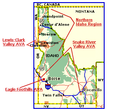
Idaho State Wine Regions
Click on the map region of
your choice to see
a more detailed map including winery locations.


Click here for Snake River Valley AVA Map
Click here for Eagle Foothills AVA Map
Click here for
Lewis-Clark Valley Map
|
To
print map, RIGHT mouse click over the map and do one of the
following:
Internet Explorer
click on the “Print Picture” option;
Firefox click on “View image” then choose Print from the
browser pull down menu; or
Safari and Chrome click on “Open image in new tab”
then choose Print from browser pull down menu. |
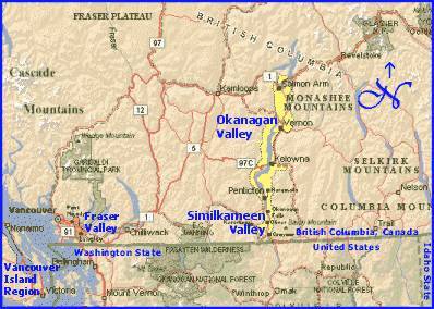
British Columbia Wine Regions
Click on the region of your
choice to see
a detailed map including winery locations.

 Okanagan and Similkameen Regions
 Vancouver Island Region
 Fraser Valley/Vancouver Region
|
To
print map, RIGHT mouse click over the map and do one of the
following:
Internet Explorer
click on the “Print Picture” option;
Firefox click on “View image” then choose Print from the
browser pull down menu; or
Safari and Chrome click on “Open image in new tab”
then choose Print from browser pull down menu. |


Copyright © 2000 -
October, 2019 Susan R. O'Hara.
All rights reserved.
Last revised:
10/27/2019
|


